
Written by Lorna Boschman and Claire Roberts
What is StoryCloud?
Working with the StoryCloud approach, artist-researchers create and share unique sound walks, also known as geolocated audio storytelling, or locative media. We upload our stories and they rain down to the electronic devices of visitors on location or online.
StoryCloud is the air between people, the empty space between us where thoughts, spoken words and images pass through a virtual cloud, triggered by our GPS location. The project helps us to connect and share our experiences of space.
As artist-researchers, we create and present community digital stories using geolocation audio. We reflect on our process, motivation and obstacles while creating the work. As designers, we look at how the work is presented so that visitors can more easily and intuitively interact. Lorna Boschman, the lead arts- and community-based researcher for StoryCloud, takes an approach that is a cross between Action Research and Grounded Theory to find a sweet spot between artists’ creative and reflective practices.
Our StoryCloud research began by examining earlier artist-led geolocation projects and the apps they used. Some apps – like Hear Us Here – were used by community- based artists and are no longer technically supported. We looked at other mobile apps, but only a few were affordable and could be embedded onto a web page. We wanted to serve both mobile device users through the app on location and virtual users through Digital Stories Canada, home of our ongoing community digital storytelling research.the


Which features were important?
The features and pricing of Sonic Maps, used by European artists and Guidemate, a German tour app used by tourist guides, artists and podcasters were most practical for our ongoing use. We realized that an app must have both a mobile interface for use with a cell phone or tablet on location as well as an off-site interface for visitors to access it remotely. For non-commercial artistic projects, the app’s service must be affordable and reliable.
Seven individual artists or artist teams created geolocation pieces for StoryCloud as a way of exploring how this technology can be used for community storytelling. Our findings are based on a close reading of each project, the artists’ evaluation after their project was completed, and subsequent discussion/reflection.
Initial StoryCloud Projects
- While learning to use the apps for StoryCloud research, Lorna Boschman created continuous sound walks in Vancouver and Surrey BC using short (under one minute) soundscapes.
- Claire Roberts’ team created soundscapes for three East Vancouver sites.
- Chris Bose created stories linked to local Kamloops art sites.
- Jerome Mandrake created a piece about coming out in Vancouver’s West End in the early 2000s.
- Jai Djwa explored his new neighbourhood in Vancouver’s West End while connecting it to his family history and Chinese migration to the West Coast.
- Michelle La Flamme explored geolocation on horseback near Burnaby Lake in her piece, Meeting a Unicorn.
- Sebnem Ozpeta collaborated with Roberto Molino as he explored street conditions related to his accessibility in Vancouver using immersive 360 video. Unlike projects that rely on the geolocation apps Sonic Maps or Guidemate (which are unable to display 360 video), Sebnem used the versatility of Google Maps to display the completed work.
Accessibility
Live visitors to a geolocation project can be charmed by the visceral experience of walking into a zone of sound. We suggest considering sites that have a bench for visitors with mobility challenges, especially for longer pieces. Several projects explored physical mobility (in a wheelchair, slower vs faster walking speeds) as we cannot assume all bodies function in the same way. Audio diversity is addressed in a limited way by including a full transcript of all spoken words in the app’s description area.
Growing out of our research as artists, StoryCloud has developed from a low-barrier storytelling concept to a practical tool for artists who work with creative communities. In defining the requirements for participation (well-recorded audio, descriptions, digital stills, GPS locations), the production process or workflow has been simplified. We are able to guide technical or non-technical storytellers toward completion of small geolocation projects. Through our work, we have established five dimensions: Memory Walks, Contemplation Walks, Educational Walks, Destination Walks and Continuous Walks.

How the Artists Approach Their Work
The StoryCloud concept developed from two separate collaborations. Lorna Boschman and Claire Roberts were developing a community storytelling approach that went beyond traditional art forms such as photography and filmmaking. Their concept began as an AR (augmented reality) approach to storytelling. With further research, we realized that geolocated audio stories represent a powerful alternative to traditional presentation formats.
As pandemic restrictions halted their in-person digital storytelling workshops at Vancouver’s grunt gallery, Lorna Boschman and Sebnem Ozpeta began holding the sessions virtually. The online storytelling workshop works well for people who are comfortable around digital technology but tends to exclude the less technically inclined who just want to tell a story. These projects transformed into our StoryCloud research which supports a growing collection of geolocated stories.
Lorna Boschman produced this collection of StoryCloud projects by discussing the project with the artists before applying for arts funding. Once funding was granted, Lorna asked each artist or artist team to choose between our two geolocation apps based on their evaluation of player interface and features.
The projects have elements of both personal and community documentation, in that they tell stories about personal experiences, informed by community context. One artist describes the experience as a “memory walk” as it emphasizes the connection between emotional experiences and geographic locations. Through the presentation of their stories in location, the artists move from personal memoir to embrace community identification and share culturally informed perspectives.


Artists’ Memories of Mount Pleasant
Michelle La Flamme created the prototype geolocation project, Artists’ Memories of Mount Pleasant, shared using the Guidemate app. Earlier, Michelle created a short video (Searching for my sister’s eyes) during our community digital storytelling workshop as she dealt with the grief of losing her sister. Artists’ Memories of Mount Pleasant grew out of her digital story as she elaborated further on her personal connection to the Mount Pleasant area of Vancouver. Michelle recognized that while her first digital story was about grief, the geolocation project was a tribute to the neighbourhood.
Artists’ Memories of Mount Pleasant begins at the grunt gallery, site of many art and performance openings attended by Michelle. The tour continues with two pieces at the Native Education Centre, a source of support for Indigenous students pursuing higher education. The tour takes us to local murals that have been significant to Michelle: “There are even more new murals…that was the walk that was foundational to my grief experience so it is very very personal and it might help others to look to the land or the environment for healing.”
Michelle’s process was to write the stories connected to nine spots in Mount Pleasant that were significant in her own development. She performed the written pieces while walking through the area, recording with the technical assistance of Lorna and Sebnem. After reviewing the images and audio, Michelle chose the Guidemate app to present her project. She preferred the lighter screen interface of Guidemate compared to the default darker screen of Sonic Maps.
Reflecting on the geolocation audio creation process, Michelle wrote “ The process flicked some of the corrosion off my hard drive and several names and faces and experiences emerged that had not been accessible before this process. I would recommend this memory walk to anyone who feels a deep connection to specific locations. I think we all do this as humans. I would recommend that the participants create a quiet debrief space or person or experience after this process.”
In addition to her suggestion that storytellers consider how to deal with challenging memories that may come up as part of the creative process, Michelle asked us to reconsider whether to record in location due to background noise and other distractions. As technical support for the storyteller, we encourage people to write or develop their stories and tell them to us, rather than reading what they have written off the page or cell phone. In this way, we try to encourage a more natural sounding vocal performance.
As a result of working away from the script, Michelle noted that several Mount Pleasant projects she wanted to mention were left behind, links between stories were forgotten, and traffic noise distracted her performance. As a result, we recognize that, unlike a commercial situation where following a script and schedule are prioritised, in community storytelling, we listen to the storyteller. As artist-technicians who work with artists and communities, we shifted our outlook on using a script following Michelle’s feedback.
Sebnem Ozpeta developed a technique to present the project on Google’s My Maps as interactive 360 images with audio, using 360 images to create a more interactive experience for viewers.


Artists’ Memories of The West End
Artists’ Memories of the West End was developed by Jerome Mandrake. Jerome recalls coming out as queer in Vancouver’s West End during the 1990s to early 2000s. At the time, he noticed a convergence of the gay male and performing arts communities. His collection of storytellers discuss their experiences at gay clubs of the era, as well as the importance of programs offered at the West End Community Centre and Vancouver’s LGBT2Q+ Centre, Qmunity. In many ways, Jerome extends the memory walk concept to include contributions from other community members.
Adopting a documentary approach, Jerome interviewed himself and several friends who gained prominence as performers in the last few decades. Jerome worked closely with the Vancouver Pride Society and was a headlining act for the annual march and festival. Spencer Stump recalls being crowned Vancouver’s Next Drag Superstar in 2014 at Celebrities Nightclub. Quinn Peters, another storyteller, is known for his performance art, as well as his volunteer work at the Pride Society, YouthCo and Qmunity. As an employee for the Queer Film Festival, PuSh Festival and Positive Living, Quinn has been introduced to many residents and stories that make up our West End community. Jerome concludes his walking tour of Vancouver’s West End with a visit to the now abandoned Polar Bear Enclosure at Stanley Park, the site of outings with his father when he was a young boy.
Jerome’s process was to reach out to artists who were part of the West End gay male community and ask them to join his project. He walked with the artists to the location representing their memories and recorded their interviews. He used Facebook to reach out to friends. In preparing for the recordings, Jerome watched old performance videos on YouTube, remembering the creative community they built in the past, one that was full of hope.
Through working on the project, he also recalled friends who had moved away or passed away. He reminds people of the thriving queer performance scene that existed at the beginning of the millennium. Jerome was “interested in exploring stories of people discovering art inspiration in the West End like I did.”


Kamloops Art Tour
Chris Bose has worked with our group of community digital storytelling practitioners since we began our research together in 2019. In the Kamloops Art Tour, Chris visits the site of two murals he created with the participation of community members. He shares background stories of how community murals were created at the Kamloops Native Education Centre and Immigrant Services Centre. Then he takes us to the Free Wall, a space where graffiti is legal. The tour wraps up relaxing with him on a bench at Peterson Creek Park, enjoying the view and contemplating.
Chris makes a connection between people and the land as a member of the N’laka’pamux/Secwepemc Nation in B.C. “It’s really important in Indigenous storytelling, we would use stories to place ourselves in the environment and the land around us. So every place had a significant story. So it would be a place where you could go fast, go out, do your vision quest on the mountain or a famous battle happened here. Or, you know, Coyote did this here and there’s cultural stuff attached to each one. And the stories weave the importance of these things in the story. And you don’t even really notice, but they’re really important. So for me as a storyteller and for me as an artist, it’s hand in hand. I get to go out on the land and show people, places where I go to chill out and places where I go to share skills and places where I go to create art and that’s placing me on the land and me in the community.”
In searching for a theme, Chris “decided to go with favourite places I like to be for contemplation and clearing your head.” This could be called a Contemplation Walk. While the Memory Walk tries to make sense of how past experiences within communities have brought us to our current state, the Contemplation Walk allows us to rest in the present, looking forward and back. Using this framing, Chris’ first two pieces about community mural making are Memory Walks, while Free Wall and Peterson Creek Park encourage contemplation.
As an experienced community digital storytelling workshop leader, Chris Bose had the skills and equipment readily available for his recordings (digital audio recorder, microphone, headphones, and computer editing software).
Chris described trying another route – comedy – but realized that humour is not always universal. Having advanced technical skills allows an artist to pivot and try another idea relatively easily.
Part of the contemplation at Peterson Creek Park is related to physical ability – it is on fairly flat ground and there is a bench to rest. The Free Wall is “is a fun one because I take kids there from my workshops and we paint. I show them how to use graffiti, how to do graffiti painting.”
Reflecting on the two community mural projects, Chris says, “I miss some of the people that were involved, you know, I don’t see them for whatever reasons they’re just people that come into your life and then they leave and that’s just, you know, part of the natural way. So I miss some of the people and for sure it was really fun. It was cool to meet a lot of new people and hear their stories. And I don’t know, help them create a community project that they can be proud of. It was awesome.”

The Talking Poles
Lorna Boschman focused on the technical and accessibility aspects of geo mapping rather than developing a new theme for her research. Lorna adapted 39 short audio clips from an earlier community art project, led by the team of T’Un T’anat – Cease Wyss, Vicki Moulder and herself, commissioned by the City of Surrey in 2009. The Talking Poles are located in Surrey B.C. Canada. As people walk by, they trigger audio clips co-created with community members and their vision for the future of the area. Growing out of our community engagement process, the twin themes of Love and Peace developed. The solar powered interactive audio components of the original sculptural artworks are a precursor to contemporary geolocation apps.
After obtaining permission from Cease and Vicki, Lorna incorporated the Love and Peace audio clips to create two Sonic Maps in Vancouver, one for slower walkers and one at a faster pace along a quiet side street/bicycle path. She also created two Sonic Maps in Surrey, one that passes the Love Pole and one that passes the Peace Pole. The two Surrey projects are mapped along the Serpentine Greenway, a popular walking path shadowed by high voltage electrical lines. Anticipating that people would listen to the audio while walking along the Greenway (or Woodland Drive in Vancouver), the Talking Poles project is intended as a Contemplation Walk on Love and Peace.
Unlike the other projects that involve travelling to a specific location (Destination Walks), Lorna created walks by placing audio clips overlapping in a sequence (Continuous Walks). Lorna compares it to walking through an automatic doorway: “I decided to have a continuous flow of sound, controlled by the moving body. When the interactor goes through each zone, they trigger a new audio clip. The content was important and interesting, but what I was most interested in was trying to create a continuous walking experience, rather than sitting down or standing around for a story.”
After downloading the audio components of the project, visitors experience it by walking through zones, triggering an audio event when moving from one zone to another. The audio clips are all under one minute in length, a mix of local voices, music, drumming and ambient sounds.
Moving forward, Lorna wonders “What will happen when we start to more consciously apply the lessons from other disciplines to geolocation audio projects? Anticipation, lies and misdirection, suspended disbelief, juxtaposition. Guessing games, game strategies.”


Echoes of Movement
John Burton and Claire Roberts (ZenCentric) collaborated on a walk through East Vancouver that incorporates ambient audio and vocalizations with a unifying theme of movement. They chose three sites – an historic rail crossing built after 1971’s blockades by the Militant Mothers of Raymur who wanted a safer route to school for their children; a community-built skateboard park located in the disused tennis court of a community centre; and the path of crow migrations over cobblestones, remnants of a decommissioned railway line from the early 1900s. John recorded ambient audio sounds and used them to create the soundscapes, while Claire contributed the vocals and text.
In retrospect, they write, “When next we approach a project such as this, we will choose locations that have places to sit, as we expect to again design pause and listen” audio, rather than walk and listen.” Lorna designed the Talking Poles route to be walked through, using the visitor’s body as controller. In contrast, the Echoes of Movement route is destination-based, with visitors walking between three sites. Although the focus of our research is on the experiences of artists as they experiment with geolocation audio techniques, we do have to consider site visitors. Is the area equipped with benches or somewhere to sit and listen to the longer audio pieces?
While recording the ambient audio, John raises a significant point: “In such a rainy environment, it’s difficult to get recordings that don’t include weather effects, and recording on-location makes one far more aware of things we take for granted (cars/traffic/ambient) that you don’t normally notice because the sound isn’t directly isolated in your headphones…Had to remember to record what’s there, not what I thought I was trying to capture.”
Since the project invites artists to consider the location, many artists responded by collecting audio in location. Photos connected to each site also show the location, which is reassuring to visitors as they arrive on site. When artists are creating the work, weather conditions including outdoor temperature must be considered. In several of the projects, the artist delayed recording until there was a break from Vancouver’s winter rain.
Claire also noted, “Initially there was some insecurity that perhaps what we had done was incorrect for the project, but as we learned more about what some of the other artists were doing, the more exciting it became, as we were all taking somewhat different approaches.” This is an interesting point, as artists and visitors alike are unsure about using geolocation audio apps for creative content. As we discuss later in the Interface design section, the interface sharing each geolocation audio project is not always intuitive. Artists were exploring two primary directions, adding a personal element to a community project, but also thinking about how to share documentary and soundscape elements with their audience.


5 Pearls
As a creative technologist and strategist, Jai Djwa works with organizations to develop digital projects. He has worked with our team of artist-researchers since our research began. His StoryCloud project, 5 Pearls, gave him the chance to explore his new neighbourhood, Vancouver’s West End. As someone of Chinese ancestry, Jai wondered “how relevant and interesting was the ocean to the Chinese diaspora?”
Jai began his research into Chinese migration to Canada’s West Coast by reaching out to scholars and visiting “the exhibition A Seat at the Table at the Museum of Vancouver. That was very helpful in understanding the different periods of immigration of the Chinese in Vancouver.” Jai found there was a lack of interest in the ocean or swimming within the documentation he found describing Chinese households in this area.
Those reflections and his own observations formed the basis of the script for each location: “Just the idea of investigating my own identity is always a challenging and revealing exercise. As I extend my understanding of the Chinese community here, I ask questions of myself such as whether I am part of that community or not. My father was Chinese-Indonesian and moved here in the 1950s, which was well after the major waves of Chinese immigration. But many of the feelings that I get from looking at the Chinese immigration makes me feel a kinship to them. It is a confusing feeling, but I enjoy the investigation of identity.”
While working on the project, Jai realized that, “I like the combination of being able to stand somewhere and listening to a story. It gives a good feeling for people to be able to share in the experience and be there at the same time. It’s sort of a kinesthetic combination that I enjoy.”
Stories are tied to a location: “The stories being related to place give an ineffable sense of continuity. I think that the stories being a part of the locale in front of you also give a different relationship to the land around to you. As you learn the stories, they become embedded in the land. First Nations talk about the land as not only being a place for things to happen but also a memory. So, if you lie about something at a particular place, that place embodies that lie until it is cleansed. That is a very different concept of the world than I hold, and I try to understand that. But with that way of thinking, perhaps the most interesting part of that is the stories told there then become part of the place.”
While testing the tour on location, Jai asked for several adjustments to the boundaries of the area where visitors would be walking. He considered a path for cyclists along the road but decided to focus on the pace of a walking tour along the seawall. He also moved the first location closer to the rest so that the walking tour would be shorter.
As a creative technologist, Jai is familiar with common recording and editing packages. Although being ill affected his vocal performance, he grew to like the quality. Most audio was recorded in location, with a few diegetic industrial sounds added later. He mixed the sound in Apple’s Logic Pro. After listening to the audio in location, he remixed the sound so that the vocals were more prominent, noting “there were some adjustments that I could make to the sound mix to compensate for the quality that emerges from your phone as opposed to my full audio speakers.”
5 Pearls is a contemplative walk, informed by personal experiences. The walking pattern is based on locations along the shore of English Bay in Vancouver’s West End. Reflecting on the piece, Jai states, “I think that people would take away the complex relationship that the Chinese had with Vancouver and white culture in general. I do feel the piece is somewhat melancholy and I like that feeling. But it is a reflective piece and maybe people will consider their own identity here in Vancouver. Maybe they would gain some further empathy for the Chinese situation if they were not Chinese or even if they were.”


Meeting a Unicorn
Michelle La Flamme’s second geolocation project, Meeting a Unicorn, was created with her friend Cappy the horse. Michelle belongs to the Burnaby Horsemen’s Association (BHA), a community-run stable located within Burnaby Lake Regional Park. Michelle created this project to introduce “this unique location in Burnaby that is a huge part of my life that most of my city friends do not even know about. My life is mostly urban but I have a country side that is connected to horses and riding. In the last few years, I have started to bring my ‘city friends’ to the barns and to meet horses I am connected with. Two of my city friends are now riders…This became the theme of the project to 1) reveal a hidden destination in the city, 2) show this side of my life and 3) introduce people to the magic of horses!”
Michelle noticed that her approach to the project shifted as she began to work with a crew. Lorna and Sebnem were her technical collaborators on Artist’s Memories of Mount Pleasant and easily moved into production mode at the Burnaby stables. Michelle wore a lavalier microphone while she performed the daily chores associated with caring for a horse. Sebnem took over a thousand photos on her cell phone during our recording session. After listening to the audio, Michelle realized that “it might be good to consider the audience more and develop a script that was a bit more mindful of the user who might be a random person walking on the trails. So, I went back and took elements from the original audio transcript and did some research on the BHA as an organization and revised the script and made it more for the listener than for my own story of how I work with the horse. Then we met again in my garden and did a few takes of the revised script in a nice relaxed setting.”
One of Michelle’s challenges was selecting the photos to use in Meeting a Unicorn. “We had around 1,000 photos and of course I feel that I love every single one as they tell the story of a horse I love and our bond. Each one offered a microsecond of that connection and so it was VERY challenging for me to put aside this personal dynamic and again, consider what might someone new to horses find interesting. What might someone on the trail using the geolocator find interesting. Again, Lorna helped me to work through this and gave me good suggestions as to how to move forward in our creative consultation chats.” Having a collaborator helps artists by giving them a chance to discuss challenges and find potential solutions.
The four locations on this tour are just outside the BHA site on public trails. Each location has a theme, introducing Cappy the horse, the Burnaby Horsemen’s Association, wildlife on the trails, and protocols when approaching a new horse.
While many of the artists we collaborate with have a media production or editing background, Michelle’s is in writing and performance. In some ways, her role as artist-researcher within our team is to help us explore the challenges that non-techies might encounter. Since she has collaborated with this team in the past, her technical challenges were fairly minor. Through working on the project, Michelle was introduced to the file transfer service WeTransfer as a way to have access to the project stills.
Michelle explained why she chose the spot: “The photos and story will explain the signage ‘Burnaby Equestrian Center’ at Avalon and Cariboo which confuses many people because it is right off Highway 1 and no one expects horses to be at this spot! … I hope a parent who has a child who is in love with horses will realize there is a place to bring their child for lessons or to visit horses on our open house days. It will also increase respectful use of the trails by multiple users, I hope!”
Michelle combines aspects of memory and education, informed by contemplation in this walk. The audio geolocations are clustered close to the entrance of the Burnaby Equestrian Centre, a destination walk.
City We Live In uses 360 video is a powerful technological tool that allows a viewer to experience a sense of place with interactivity. Viewers can scroll to show another viewpoint within a 360 degree video image. In a sense, this places Roberto Molina, a paraplegic athlete, at the centre of the frame with the world moving around him. This is a new, alternative, digital storytelling where the viewer can experience reality in a closer way by showing ‘the whole picture.’ This form of storytelling differs from traditional cinema’s fixed or sequential viewpoints.
In this project artist-researcher Sebnem Ozpeta asked the question “How can we use this technology to raise awareness of accessibility?” and “How can we make this tool more useful to improve public engagement and lead to some questions on accessibility?” Sebnem has worked as part of our research team since the first project.
Sebnem interviewed Roberto Molina, an immigrant from El Salvador who is paraplegic and has a loss of use and feeling in his legs. Roberto shared his experience of being in a wheelchair while filming 360 video and by experimenting with perspective and point of view. In following this approach, they attempted to increase the audience’s understanding of particular situations that people who use mobility devices encounter in the City We Live In.
As arts organizations and artists learn more about accessibility and inclusion, we can work on ways for others to learn as we do. Sebnem’s collaboration with Roberto involved meeting to discuss the project, recording and editing the audio, the lengthy process of setting up a 360 video project, and processing the final 360 video. At first, Sebnem tried to record an empty street but could not avoid including her own image. When the location of the 360 camera shifted to Roberto in his chair, the resulting image was a better match for the soundscape.
In the future, we hope that our research will lead to city mapping projects involving 360 video. By artists and communities working together, we can map the barriers to accessibility for physically challenged people in the places where we live.
Designing for User Experience
Our original research objective was to examine interaction from the artist-researcher’s perspective. We learned that geolocation audio apps should be affordable, and allow artists to upload text and photos linked to a specific location. Most of the artists who created content to test the parameters of the apps were technically able to record and mix their audio, and provide photos and text for their recordings. To avoid the extra step of learning to use the apps, Lorna Boschman mapped all of the StoryCloud projects, except for the 360 video project created by Sebnem Ozpeta.
While the earlier sections in this document deal with the artist-researcher’s perspective, we now turn to the visitor’s or user’s outlook. We found that using these apps is a novel experience for visitors who would like to experience StoryCloud projects. We chose two geolocation audio apps to work with in our research, Sonic Maps and Guidemate. Both offer a mobile version for use onsite or remotely, as well as an embedded version for remote visitors at a tablet or desktop. A web version was important to us. It serves visitors who live with mobility challenges, are located outside our geographic area, or prefer to experience community digital storytelling at home.
As we worked with the apps, it was clear that these represent two distinct categories of users. Onsite users tend to have a data plan on their mobile device, are close in proximity to the audio zones, and are comfortable using GPS on their devices. Remote visitors use mobile devices or desktop computers disconnected from the GPS features. Below, we share our iterative design process exploring the needs of each type of visitor. We based the design on feedback from the artists who were testing the mobile app with their friends.
Addressing Visitor Challenges
Geolocation audio apps are optimised for live visitors, using GPS to trigger zones of audio recordings on a mobile device. In designing for visitors to StoryCloud, we realized that both Guidemate and Sonic Maps worked well in the field as a mobile app. Sonic Maps was less intuitive when embedded on a web page.
Visitors arriving at a webpage do not always know how to interact with an embedded app. To address this, we tried adding more instructions. We soon realized that people will not wade through those instructions to arrive at the digital story. Our solution was to think about what people want – to read a short description and hear the audio by clicking a play button. Instead of embedding the Sonic Maps app, we uploaded the audio files and photo to SoundCloud and embedded that interface into the site for remote visitors. There is still a link to the Sonic Maps version of the project where visitors can download the files and use GPS for the full onsite experience.


While the embedded Sonic Maps interface was less intuitive, there are a number of features in the app that are appealing. Projects can be shared privately using an email address. The shape of the GPS-enabled zones can be customized. Guidemate relies on a circle configuration and cannot easily replicate the Continuous Walk technique or provide customized GPS-enabled shapes for the audio zones.
An added factor relates to page (download) speed. If photos are less compressed or more coding is added to a page, the length of time it takes for the page to appear on a mobile device or computer increases. While two or three SoundCloud audio files embedded on a page will not have a large impact, five or more will slow the page considerably. For the StoryCloud projects that include more than five locations, audio clips were combined to create fewer SoundCloud files to embed on the page.
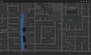
On the StoryCloud webpages, we added a graphic map, created by Claire Roberts. The map gives a quick reminder of the tour locations by street. This functions as an additional reminder that the projects are geolocated, even when they are viewed at home on a computer or mobile device.
Future Research
As artist-researchers, we have begun to explore how geolocation audio apps and 360 video can be used to tell community digital stories connected to a specific place. Since 2019, we have shared our research into community digital storytelling on the Digital Stories Canada site. Next we propose a Portal for Community Digital Storytelling.
Online portals are commissioned to provide personalized training, organize discourse and files, and direct engaged workflow. The Community Digital Storytelling Portal will promote resilience for Canadian artists and encourage their digital literacy through creative collaboration. Lorna Boschman and Sebnem Ozpeta have facilitated online digital storytelling workshops since 2020 and will create a portal experience based on these workshops.
Within the sector of digital and media artists who work in a community practice, a Portal offers the opportunity to return to work without disruption. Except for short periods of low covid numbers, digital storytelling facilitators and mentors have not been able to engage in live workshops. Even with protocols in place, artists with higher health risks may still hesitate to attend live workshops. By using the Portal, facilitators can shift online as needed, and offer live instruction if it is acceptable for workshop participants. This flexibility allows the workshop to proceed regardless of public health barriers.
There is a gap in collaborative learning for artists who want to engage more fully with digital methods. Our workshop, presented through the Portal, provides a unique opportunity for artists. As long-time facilitators, we embrace customized learning experiences (user-centred learning) rather than overview curricula. A Portal helps to focus on the individual needs of each artist-participant, challenging them to learn new digital approaches while completing a short storytelling project.
Communicating while learning something new can be a challenge, as artist-participants may not be familiar with digital terms and approaches. The Portal supports synchronous (chat, video conferencing) and asynchronous (email, technical forum) communication between participants and facilitators, helping artists to track their progress and get timely support. Our workshop trains artists to find and implement new knowledge through digital storytelling practice. Ideally, the Portal provides a hybrid live and digital experience, encouraging artists to experiment with digital approaches.
